Walks in the Scottish Highlands

map key
walk locations
map key

1. Ben Nevis

Route Map

Miles: 10 (16 km)

Maps: OS Landranger 41

baa
walk locations

Details:

This is Britain’s highest mountain at 5,450ft (1,344 metres).

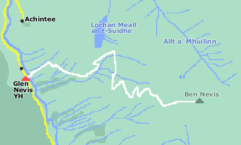
The quickest way to the top is to begin at Glen Nevis Youth Hostel, 2 miles SW of Fort William. Pace yourself because you have a very steep 5 mile climb ahead, but on a good wide track all the way to the summit.

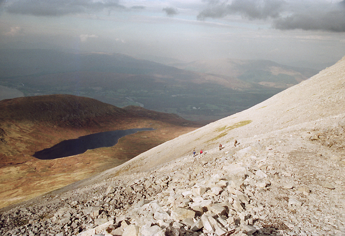
A warning – if there’s snow on the summit, be sure not to walk too close to the edge. The snow conceals the edges and you could be walking with no solid ground underneath.

On the way to the summit

2. Falls of Glomach

Route Map

Miles: 12 (19km)

Maps: OS Landranger 33

baa

Details:

These falls are definitely worth the long hike. You begin at Morvich 3 miles NW of Sheil Bridge.

From the falls there is no obvious path, but keep to the west side of the river named Abhainn Gaorsaic on the map and continue to Loch Gaorsaic. You will now join a path that takes you up to Bealach an Sgairne and then all the way back to Morvich.

around morvich
Views on the way up
around morvich
Views on the way up

3. Torridon

Route Map

Miles: 5.5 (9km)

Maps: OS Landranger 25

Details:

A relatively easy walk covering track and path three miles south west of Kinlochewe.

Parts of the route are lined with rhododendrons and you can catch them in flower during May and June. The path can be a little muddy around the north eastern side of Loch Coulin, but the impressive views of Beinn Eighe over to the north west compensate. All in all, this is a very enjoyable walk.

torridon
Around Torridon
torridon
Around Torridon

4. Lochinver

Route Map

Miles: 15 (24km)

Maps: OS Landranger 15

Details:

A circular walk that includes the Eas a’ Chual Aluinn waterfall and with a drop of 658 feet (200 metres), it’s Britains highest. You can begin the walk at Inchnadamph where parking is available.

Navigation skills will be useful because occasionally the path can be elusive, but for most of the time the route is straightforward. A short diversion takes you to the top of the Eas a’ Chual Aluinn waterfall.

This is one of my favourite walks but I did it in a heat wave, so not the best time for a full effect waterfall, yet certainly enjoyable.

lochinver
On the way
lochinver
On the way

5. Sandwood Bay

Route Map

Miles: 12 (19km)

Maps: OS Landranger 9

Details:

You can leave your car at Blairmore and there is a good track to Sandwood Bay.

At the bay you have a mile of deserted sands to explore, with views of Am Buachaille (a single rock stack) in the distance.

There isn’t a path shown on the map around the shore of Sandwood loch, nor beside Strath Shinary, but on the ground you will find one and the way ahead is straightforward.

deserted
No ice creams

Any product links included on this site are the most appropriate for backpacking and will save you time searching!
As an Amazon Associate, I earn from any qualifying purchases at no extra cost to you.

3 sheep
deserted
It's a bit stormy!

Any product links included on this site are the most appropriate for backpacking and will save you time searching!
As an Amazon Associate, I earn from any qualifying purchases at no extra cost to you.

3 sheep